


1925 Santa Barbara Earthquake
How Disaster Led to the Rebirth of an Iconic Coastal City

On June 29, 1925, at 6:44 a.m., a magnitude 6.8 earthquake struck Santa Barbara, California, killing 13 people and damaging 85% of the buildings in its downtown commercial center.
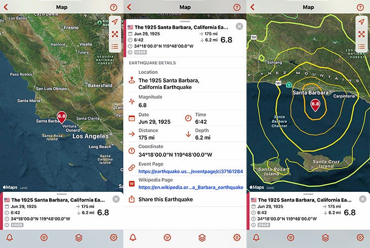
The 1925 Santa Barbara earthquake in the QuakeFeed app, showing earthquake details and MMI contours (shaking intensity).
Basic Facts
Location: Santa Barbara Channel, offshore from Santa Barbara, California
Date & Time: June 29, 1925 at 6:44 a.m. PDT
Magnitude: 6.8 Mw (estimates vary)
Depth: Shallow offshore earthquake
Fault System: Extension of Mesa Fault or Santa Ynez system (offshore)
Maximum Intensity: VIII (Severe) on the Modified Mercalli Intensity Scale
Felt Area/Population Affected: From Paso Robles (north) to Santa Ana (south) to Mojave (east)
Tectonic Setting: Santa Barbara Channel, part of Transverse Ranges system
Impact Summary
The 1925 Santa Barbara earthquake resulted in 13 deaths and caused an estimated $8 million in damage (approximately $145 million in 2025). Had the earthquake struck during business hours when the city center was crowded with people, the death toll would likely have been higher. About 85% of the buildings in downtown Santa Barbara were damanged or destroyed, nearly every chimney in the city collapsed, and the bell towers and facade of Mission Santa Barbara were severely damaged.
During the earthquake, the soil beneath the earthen Sheffield Dam liquefied, causing the dam to collapse and release a torrent of water that swept seaward, carrying trees, boulders, and urban debris.
Thanks to the quick thinking and bravery of three night engineers, Santa Barbara was spared the widespread fires that devastated cities like San Francisco in 1906. Amid the violent shaking, they swiftly cut power and gas to the entire city, preventing fires, saving lives, and shielding the city from further destruction.
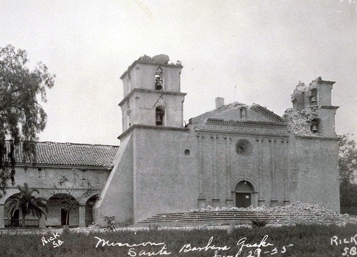
Mission Santa Barbara showing damage to its facade after the 1925 earthquake, including lost bell tower statues and structural damage to the twin towers. Photo credit: UC Berkeley, Bancroft Library
Notable Facts
Dam failure milestone: The Sheffield Dam collapse was the only dam to fail during an earthquake in the U.S. until the Lower Van Norman Dam was damaged in the 1971 San Fernando earthquake.
Complete architectural transformation: The 1925 Santa Barbara earthquake gave the Santa Barbara Community Arts Association the opportunity to rebuild the city center in a unified Spanish Colonial Revival style. This cohesive aesthetic—white stucco buildings with red-tiled roofs, arched doorways, and intricate wrought-iron details—became emblematic of Santa Barbara's identity. Iconic landmarks like the Santa Barbara County Courthouse showcase this enduring elegance that defines the city today.
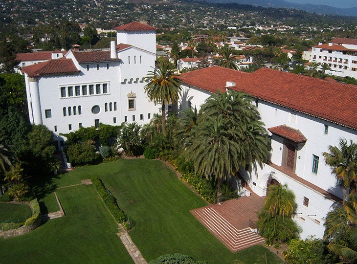
The Santa Barbara County Courthouse, built between 1926 and 1929, embodies the distinctive Spanish Colonial Revival style. Photo credit: Konrad Summers
Scientific Significance
The absence of fires in Santa Barbara following the earthquake provided a rare laboratory for earthquake science. Engineers and seismologists could study pure seismic damage without fire obscuring the destruction patterns. They discovered that unreinforced masonry buildings crumbled while wood-frame structures survived.
This clear evidence led Santa Barbara to adopt California's first comprehensive seismic building codes. The city's coordinated rebuilding—mandating both earthquake-resistant construction and unified Spanish Colonial Revival architecture—became the template for disaster recovery that prioritized safety without sacrificing beauty, influencing urban planning across earthquake-prone regions.
The event also highlighted the importance of emergency response, as the three heroes who shut off the town's gas and electricity prevented what could have been a catastrophic fire, potentially saving many more lives.
Get the QuakeFeed App
Curious about historical earthquakes? Download QuakeFeed from the iOS App Store to explore thousands of earthquake events on an interactive map. Activate the 30-day Free Trial for QuakeFeed Premium to view the historical earthquakes.
View the 1925 Santa Barbara Earthquake in QuakeFeed
Open QuakeFeed and tap the Data Source button (second from left).
Tap Earthquake Source and Filters at the top.
Select Change Data Source → USGS Historical
Select USGS Since 1900, U.S. Lower 48.
Tap Next → Finish → Done.
In the search box, type 1925.
Tap 1925 Santa Barbara, California to view it on the interactive map.
Pull up the details panel for links to the USGS event page, Wikipedia, and more.
Tap the Map Settings button (third from left) to add layers like Faults and MMI Contours.
Continue Learning
USGS Event Page: M 6.8 1925 Santa Barbara Earthquake
Wikipedia: 1925 Santa Barbara earthquake
Southern California Earthquake Data Center: Santa Barbara Earthquake 1925
Santa Barbara Historical Museum: 1925 Earthquake
Noozhawk: How 1925 Santa Barbara Earthquake Shaped the City’s Style Today
Santa Barbara Independent: Santa Barbara Earthquake Survivor Stories
Be Prepared
Anniversaries of major earthquakes like the 1925 Santa Barbara quake remind us that earthquakes can strike without warning. Preparation is the key to responding effectively and recovering quickly. Take this opportunity to refresh your emergency supplies and review your family's safety plan. Earthquakes may be unpredictable, but your response doesn't have to be.