


1992 Landers Earthquake
M7.3 earthquake left a 43 mile long scar in the Mojave Desert

On June 28, 1992, at 4:57 a.m., a magnitude 7.3 earthquake struck near Landers, California, becoming the largest earthquake in California since the 1952 Kern County earthquake.
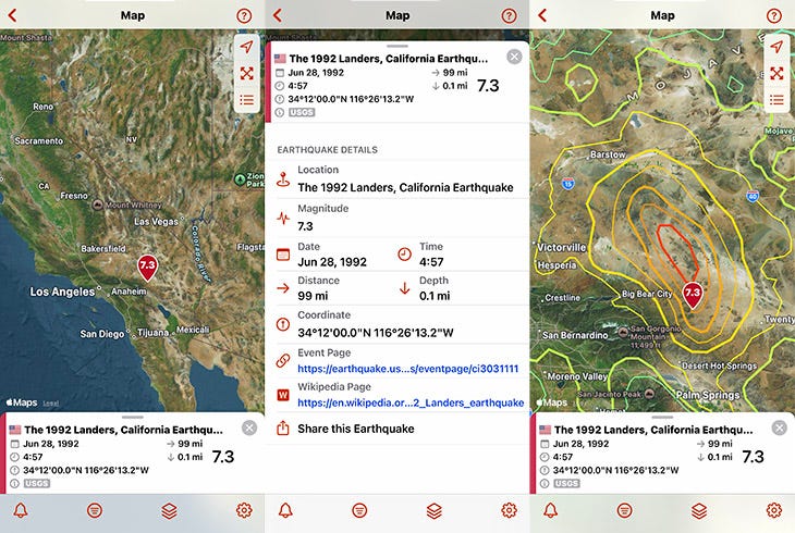
The 1992 Landers Earthquake in the QuakeFeed app, showing earthquake details and MMI contours (shaking intensity).
Basic Facts
Location: Near Landers, San Bernardino County, California (Mojave Desert)
Date & Time: June 28, 1992 at 4:57 a.m. PDT (11:57 UTC)
Magnitude: 7.3 Mw (originally 7.5 Ms)
Depth: Shallow (approximately 0.68 miles/1.09 km)
Fault System: Johnson Valley, Homestead Valley, Emerson, and Camp Rock faults
Maximum Intensity: IX (Violent) on the Modified Mercalli Intensity Scale
Felt Area/Population Affected: MMI VI (Strong) zone covered 18,100 square miles; felt across Southern California
Tectonic Setting: Central Mojave Desert, part of Eastern California Shear Zone
Impact Summary
Striking a sparsely populated area, the 1992 Landers earthquake caused 3 deaths and over 400 injuries. Two people died as a result of heart attacks, and a 3-year-old died when bricks from a chimney collapsed into the room where he was sleeping.
Damage to infrastructure and property in the area directly surrounding the epicenter was severe. There were large surface fissures. Roads were cracked and offset, including major highways and desert access routes. Buildings sustained structural damage, with numerous homes experiencing collapsed chimneys, cracked foundations, and broken windows. Utility lines were disrupted, and one fire station and several commercial structures required repair. The total property damage was estimated at $92 million.
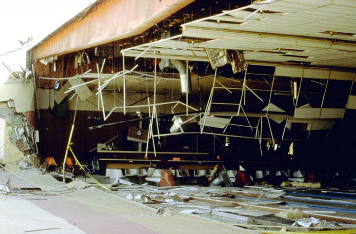
Damage to Yucca Lanes Bowling Center shows collapsed ceiling and scattered debris from intense shaking near the epicenter. Photo credit: USGS
Notable Facts
1. Massive surface rupture: A continuous surface rupture extended for 43 mi (70 km), with a maximum horizontal displacement of 18 ft (5.5 m) and a maximum vertical displacement of 5.9 ft (1.8 m).
2. Complex fault sequence: The earthquake was a right-lateral strike-slip event and involved the rupture of several different faults over a total length of 47 to 53 mi (75 to 85 km). The rupture connected previously separate fault systems, surprising scientists who had considered them independent structures.
Scientific Significance
The Landers earthquake provided crucial insights into how multiple fault systems can rupture in sequence during a single event.
Seismologists identified two main sub-events: the first initiated on the Johnson Valley Fault near the epicenter in Landers, and the second, larger sub-event occurred about 25 miles (40 km) north along the Emerson and Camp Rock faults, where the greatest slip and energy release were observed.
The event also demonstrated the value of the Alquist-Priolo Earthquake Fault Zoning Act, with approximately 55% of the surface rupture occurring within previously designated special studies zones.
Additionally, the earthquake triggered seismic activity as far as Yellowstone National Park—over 750 miles (1,200 kilometers) from the epicenter—challenging the assumption that large quakes only affect nearby faults. This remote dynamic triggering showed that seismic waves can alter stress conditions on distant faults, sometimes initiating earthquakes hours or days later, and reshaped understanding of how seismic energy redistributes across regions.
Get the QuakeFeed App
Curious about historical earthquakes? Download QuakeFeed from the iOS App Store to explore thousands of earthquake events on an interactive map. Activate the 30-day Free Trial for QuakeFeed Premium to view the historical earthquakes.
View the 1992 Landers Earthquake in QuakeFeed
Open QuakeFeed and tap the Data Source button (second from left).
Tap Earthquake Source and Filters at the top.
Select Change Data Source → USGS Historical
Select USGS Since 1900, U.S. Lower 48.
Tap Next → Finish → Done.
In the search box, type 1992.
Tap 1992 Landers, California to view it on the interactive map.
Pull up the details panel for links to the USGS event page, Wikipedia, and more.
Tap the Map Settings button (third from left) to add layers like Faults and MMI Contours.
Continue Learning
USGS Event Page: M 7.3 - Landers, California Earthquake
Wikipedia: 1992 Landers earthquake
USGS: 1992 Landers Earthquake
California Geological Survey: The Landers-Big Bear Earthquakes
Be Prepared
Anniversaries of major earthquakes like the 1992 Landers quake remind us that earthquakes can strike without warning. Preparation is the key to responding effectively and recovering quickly. Take this opportunity to refresh your emergency supplies and review your family's safety plan. Earthquakes may be unpredictable, but your response doesn't have to be.